From the comments: Black-Latino-white segregation in NYC

This is too good not to make a separate post: commenter Neil, or “nei,” on some of the historical differences in racial segregation between NYC and Chicago. Read it first. I add a few thoughts at the end.

Talk to Me Like I’m Stupid is working!

***

I’m going to a add a few comments on NYC that might be insightful even though they’re a bit of a nitpick. First, I’m not sure if this a good assumption:

But in New York, black neighborhoods have become significantly mixed, in particular with people of Hispanic descent.

You’re assuming those neighborhoods were entirely black at one point and then hispanics came later for some reason. I don’t think that’s a good assumption, I’d guess they arrived at roughly the same time. Large-scale migration of hispanics into NYC started mainly in the 50s, and was mostly Puerto Ricans, looking at wikipedia numbers it looks like the Puerto Rican influx was slightly earlier than the black migration, which continued into the 60s and later. The poorest Puerto Ricans settled in the some of the same areas as blacks. The South Bronx was roughly equally hispanic (Puerto Rican) and black around 1970, today it’s about 2/3rds hispanic but with a more diverse mix of hispanics. The housing projects also become dominated mainly by blacks and Puerto Ricans, though some projects are mostly blacks and others mostly hispanic, though I suppose. Hispanics average significantly lower income-wise than blacks in NYC, and NYC Puerto Ricans tend to below average income-wise among NYC hispanics, I’d guess Puerto Ricans were poorer than blacks then, too. Unskilled, discriminated against with the added difficulty of a language and cultural barrier. The many that had little money moved to the cheapest and worst neighborhoods the city had to offer, which often had a large black population. In many ways, back then, it makes sense to group hispanics and blacks together, especially pre-1980. But…

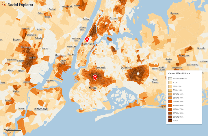
It appears blacks triggered faster “white flight” than Puerto Ricans. Many Puerto Ricans lived amongst blacks, but there were many more mixed white & Puerto Rican neighborhoods than white & black neighborhoods. For example, Williamsburg, Brooklyn pre-gentrification was mixed Puerto Rican and white (mainly Italian-American); still has some Puerto Ricans left. I think there were a number of other similar neighborhoods, but not so many stable mixed white-black neighborhoods. If you look at sites with old maps by race, such as socialexplorer.com (you’ll need the professional edition), the black population was far more concentrated than the hispanic population. Looking through by decade, you can see census tracts near a black neighborhood shift from mostly not black to mostly black. Want to guess which neighborhoods would have a quick decrease in white population? Check the black population map a decade before, areas adjacent would lose whites. Hispanics weren’t as segregated, which suggests that white flight was more of a racial than just an economic thing. Violent crime rates were higher among the black population, but in the late 70s/early 80s the hispanic/black difference was small, suggesting both populations were equally “ghettoized” in some sense, but fear of blacks seemed to cause more white flight than fear of hispanics.

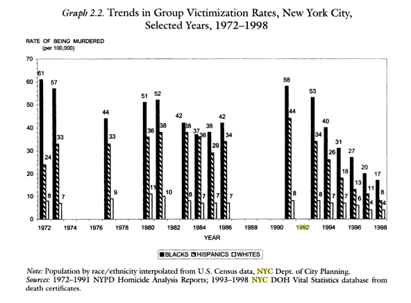
Hispanic Murder rate dropped more than blacks, probably partly from heavy immigration starting in the 80s onward as well dismantling of drug gangs. 2011 rate was 1.4/100k for whites, 5.9/100k for hispanics, 14.6 for blacks and 1.5 for Asians.

Here’s a screenshot of a map of black population in NYC, 1970 [didn’t take a screenshot of a similar map for hispanics]

Chicago looked very different in 1970:

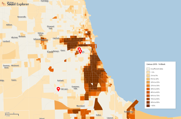
both from socialexplorer. It appears the equivalent of the South Bronx in Chicago in the 70s/80s would have been entirely black, rather than mixed black-hispanic. From what I can tell “white flight” in NYC came in two types:

1) Sudden very quick transformation from mostly white to minority. Usually more often from an influx of blacks then hispanics, and occurred in the poorest white neighborhoods, but generally mainly by near an increasing black population (block busting). Usually had white flight in the 60s or early 70s. South Bronx, Northeast Brooklyn are the best examples.

2) Gradual decrease of white population, starting later maybe in the 70s. Younger generations of whites slowed moved away, I heard them being described as “grandma neighborhoods”, since the non-transplant whites are older. They have often have some white population left, and a large immigrant population, but almost no black people (sometimes every possible race besides black). Southern Brooklyn and a lot of Queens are good examples of these places. While they were majority white, blacks were often discouraged from moving in by implied threats of violence.

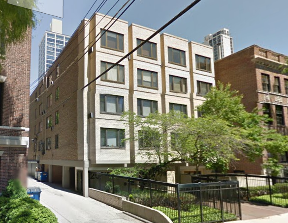
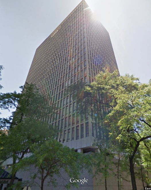
Here’s an odd pattern. The three blackest zip codes in NYC are actually well off by city standards.

Top on the list (zip code 11411) has a median income of $81k/year, median home price of $404k. 93% black, 38% foreign born. Random streetview:

cambria

My guess is it’s too expensive for poorer hispanics (mostly owner-occupied homes), and whites or middle-class hispanics see little reason to move there, while some middle-class blacks want to move to a nice black neighborhood. Of course it was white at one, a bunch of synagoues in the area stand out as an odd relic, a couple have been bought by churches. Again, the white flight must have racial rather than economic as it’s not really any poorer than white neighborhoods in that area of Queens/Nassau.

The black population of NYC has a large immigrant contingent, but instead of black immigration breaking down segregated neighborhoods, it helped keep their setup. Since 1980, the black population has had a large domestic out-migration with the black numbers balanced by black immigration (mainly from the Caribbean but also from Africa). I saw numbers saying in 2000, 40% of NYC’s black population was either foreign born or had one foreign born parent. Most black immigrants moved to existing black neighborhoods, keeping the same segregation pattern. One interesting exception is some neighborhoods in Queens, there’s a section that’s mixed asian-black-hispanic. The largest black area of NYC [Northeast Brooklyn, with a larger black population than South Side Chicago] hosts the West Indian parade annually (maybe the city’s largest parade).

There are a number of neighborhoods in NYC that experienced white flight that have no black people. Sunset Park, Brooklyn has few white people, it had large-scale white flight around the time of de-industrialization around 1970. Puerto Ricans replaced the exiting whites, but no blacks. Today, western half of it is hispanic (mix of Puerto Rican and Mexicans), the eastern half is Chinese. The switch between the two groups happens in about a block, it’s a bit jarring. Continue east further, and it’s almost entirely Hasidic Jewish (Borough Park) with another quick transition. Almost no blacks today in any of those places. Washington Heights switched from White to Dominican rather quickly, you have it labelled as <10% black, though it has plenty of black hispanics.

***

Daniel again: It actually occurred to me when I was writing the original post that I didn’t know when the integration of blacks and Hispanics happened in NYC, and I’m glad someone set me straight about that. It’s an interesting point, although there has to be a much longer and more complicated story about why they ended up together: I guess maybe the lateness of arrival of Chicago’s Hispanic community? Or were Mexicans (the largest Latino group in Chicago, by far) less inclined to live in black neighborhoods than Puerto Ricans for some reason? Or were New York’s black neighborhoods somehow more attractive?

I did know about New York’s black community’s large foreign contingent, which really doesn’t have a parallel in Chicago. Chicago’s Caribbean and African immigrants are much fewer, but they also tend to move to the North Side’s small black communities in Uptown, Edgewater, and Rogers Park, rather than the main segregated black neighborhoods on the South and West Sides. I don’t think there are any segregated black community areas in Chicago that are more than one or two percent foreign-born.

In other ways, this description is very applicable to Chicago.

The distinction between rapid and slow white flight, for example – although the vast majority of cases with black neighborhoods were rapid, there’s been some slower white flight – and lots of “Grandma neighborhoods” – on the Southwest Side, where Latinos and Asians have been replacing whites for ten or twenty years.

The distinction between “racial” and “economic” white flight, I’m not sure I fully endorse, but it does complicate the narrative somewhat to point out the places where black newcomers actually outranked their would-be white neighbors economically, but the whites left anyway. That also has a few parallels in Chicago – Calumet Heights, I believe, and a few other places on the far South Side – places that are solidly middle class, but are still shunned by non-blacks.

Anyway. Thanks, Neil, for this.

How segregated is New York City?

Update: I wrote this in the comments, but several people have asked about it and not everyone makes it down there: this post focuses on white-black segregation because that, for various social and historical reasons, has been by far the most significant geographic separation in American cities, certainly in the Midwest and Northeast. But by far the second most significant separation – white-Latino segregation – is also very extreme in New York. The same Census analysis that found NYC was the second-most-segregated metro area in terms of white and black people found that it was the third-most-segregated metro area in terms of white and Latino people. That’s obviously not the end of the story either, though. If you know about or are curious about some other aspect of segregation, leave a comment.

***

The online reaction to the recent reports on racial segregation in New York state’s public schools reminded me, yet again, that most people think of New York as an integrated city, and are surprised or incredulous when that impression is contradicted.

This is somewhat jarring, since virtually every attempt to actually measure racial segregation suggests that New York is one of the most segregated cities in the country. This University of Michigan analysis of 2010 Census data, for example, suggests that New York is the second-most-segregated metropolitan area in the U.S., exceeded only by Milwaukee, and that about 78% of white and black people would have to move in order to achieve perfect integration. (Chicago’s corresponding number is just over 76%, good enough for third place.)

Why is this so surprising? One obvious reason, I think, is that most people’s conception of New York is limited to about 1/2 of Manhattan and maybe 1/6 of Brooklyn, areas that are among the largest job and tourist centers in the world. As a result, they attract people of all different ethnic backgrounds, especially during the day, even if the people who actually live in those areas tend to be monochromatic. Imagine, in other words, trying to judge racial segregation in Chicago by walking around the Loop and adjacent areas: you would probably conclude that you were in a pretty integrated city.

But it goes beyond that, I think. Segregation in New York doesn’t look like segregation in Chicago, or a lot of smaller Rust Belt cities. For one, there just aren’t very many monolithically black neighborhoods left in New York. Here, for example, I’ve highlighted every neighborhood that’s at least 90% African American:

NYB90

Were we to do this in Chicago, half the South and West Sides would be lit up. But in New York, black neighborhoods have become significantly mixed, in particular with people of Hispanic descent. This is a phenomenon Chicagoans are used to in formerly all-white communities – places like Jefferson Park or Bridgeport, which as recently as 1980 were overwhelmingly white, now have very large Latino and Asian populations – but in New York, it’s happened in both white and black neighborhoods.

That said, white folks in New York have still on the whole declined to move to black areas, except for some nibbling along the edges in Harlem and central Brooklyn. That means that instead of measuring segregation the way we might in Chicago – by looking for very high concentrations of a single ethnic group – it makes more sense to look for the absence of either white or black people.

Here, then, I’ve highlighted all the places where white people make up less than 10% of the population:

NYW10

It’s a lot. And, correspondingly, here are all the places where black people make up less than 10% of the population:

NYB10

It’s also a lot. And if we put the two maps together, we see that these two categories cover the overwhelming majority of NYC:

NY10

The same pattern holds pretty well if we lower the threshold to no more than 5% white or black:

NY5

And there are even a significant number of areas that are truly hypersegregated, with fewer than 2% of residents being either white or black:

NY2

Because I now love GIFs, here’s a summary GIF.

NYSeg

What does all this tell us? For one, it confirms graphically what the Census numbers suggested, which is that the median black New Yorker lives in a neighborhood with very few white people, and vice versa.

But it also suggests a racial landscape that looks different from that of Chicago, and lots of other American cities, in important ways. In particular, where Chicago has a relatively simple racial geography – white neighborhoods at various levels of integration with Hispanics and Asians to the north and northwest, black and Hispanic neighborhoods to the south and west, with only a few small islands like Hyde Park and Bridgeport that break the pattern – New York’s segregated neighborhoods form a more complex patchwork across the city. That means that while a North Sider in Chicago might go years without having to even pass through a black neighborhood, lots of white New Yorkers have to get through the non-white parts of Brooklyn or the Bronx to reach job and entertainment districts in Manhattan or northern Brooklyn.

I imagine that structural-geographic fact, combined with New York’s relatively high level of black-Hispanic integration, goes a long way to explaining my anecdotal experience that white New Yorkers tend to be less ignorant and scared of their city’s non-white neighborhoods than white Chicagoans are of Chicago’s. (There’s some interesting research that suggests white people tend to be more sympathetic to brown people, and their neighborhoods, than black people and theirs.) There’s also, of course, the fact that Chicago’s segregated non-white neighborhoods tend to have much higher violent crime rates, and much more modest business districts, than New York’s, although that’s likely both an effect and cause of their relative isolation.

All of this is another reason that I’m kind of excited about the growing entertainment and shopping district on 53rd St. in Hyde Park, since the more that the South Side has “neighborhood downtown” strips that draw people from across the city, the more likely North Siders and suburbanites are to travel through the black and Latino neighborhoods that surround them, observe that many of them are actually quite nice, become less committed to shunning them, and thus contribute less to the social and economic dynamics that have created the institution of the ghetto, and the poor job prospects, failing schools, and high crime rates that accompany it.

In conclusion: New York is super segregated, but the numbers aren’t everything.

Also, let me have another Talk To Me Like I’m Stupid moment: suggestions for books about the racial history of New York? What’s the equivalent of Making the Second Ghetto or Family Properties? I’ve already read Caro’s Moses book.

Something is missing here…

One goal of beating the housing supply drum over and over again on this blog is to get to the point where general interest Chicago media outlets understand the relationship between new development and housing prices and explain it to their readers. Which is why I was incredibly excited yesterday to see a headline in Crain’s called “Why Rents Are Rising on the North Side.”

And why are they? Because there’s no new supply in neighborhoods like – surprise, surprise – Lincoln Park and Lakeview!

As more construction cranes sprout in downtown Chicago, they remain rarer in neighborhoods such as Lincoln Park and Lakeview. Stuart Handler likes it that way.

With few apartment developments going up in North Side neighborhoods, landlords like Mr. Handler have more freedom to raise rents than do owners of downtown high-rises, which are starting to feel the impact of a major construction boom that shows few signs of ebbing.

Incidentally, here is Mr. Handler’s photo in Crain’s:

 - Stuart Handler, CEO of TLC Management Co., steered clear of downtown Chicago. “I didn't want to battle it out with new high-rises.” He's glad he did.

So, um, all the social justice folks who think fighting development equals fighting gentrification, this old white guy in a suit sitting in front of a gold-plated fireplace just wants to say thanks.

Anyway, this is grade-A stuff so far, since it’s pretty rare for mainstream outlets – even business-oriented ones like Crain’s – to so directly make the link between a widespread shortage of housing supply and rising prices. I’ll be even happier when it gets in the Tribune, but I’ll take this for the moment.

But then the author gets to why, exactly, there’s so little supply in the neighborhoods and so much downtown, and it seems like there’s something missing:

Yet construction has been limited in the neighborhoods because it’s hard to find land for big projects, and rents in many places are not high enough to justify a new building, Mr. Kiser says.

In general, rents must hit around $2 per square foot, at a minimum, to justify the cost of a new building. Many existing structures on the North Side aren’t getting that, while downtown apartments are fetching $3 per square foot or more.

It may be true that there are fewer large empty lots in Lincoln Park than there are in, say, the West Loop, but anyone who’s taken a walk around knows that there are more than a handful of empty or dramatically under-utilized spaces. As for the idea that rents aren’t high enough: I’m not a real estate expert, but Zillow reports that the average rental price per square foot is currently at $2.07 in Lincoln Park. A number of other neighborhoods are quite close to an average of $2/sq. ft., which suggests there ought to be a fair number of spots that hit the magic number. Moreover, where huge empty lots have forced the issue of redevelopment – at Children’s Memorial Hospital, for example, or the New City lot near North and Clybourn – private developers have been more than eager to build, and build big.

In any case, it’s remarkable that Crain’s did not see fit to mention, at least in passing, that a notable constraint on adding lots of supply to places like Lincoln Park is that it’s illegal to do so. Or that, unlike downtown, any building over four stories or so is subject to the veto of powerful and wealthy local residents who are opposed to any new development, often explicitly on the grounds that it might promote more affordable housing.

In conclusion: Lots more articles about the link between housing supply and housing prices, please, but don’t ignore the role of zoning next time.

Excellent news for Ashland BRT

Not to get too DC-tea-leaves-read-y here, but this is really excellent news:

EAST VILLAGE — A neighborhood group Monday night narrowly voted against the “bus rapid transit” plan for Ashland Avenue in its current form after months of debate.

“At the very least, it says to the city — the CTA, the Chicago Department of Transportation — they need to do additional planning,” East Village Association President Neal McKnight said of the 11-9 vote. (my emphasis)

[snip]

“I want to be aspirational,” [Association President] McKnight said. “I want [it] to be better than what they’re offering us, and I think that what they’ve offered us is kind of half-a**ed at this point.”

So the neighborhood from which the most vitriolic opposition to Ashland BRT has come had its formal vote, and only opposed the project by the narrowest margin possible. Moreover, only eleven people actually cared enough to come out and actually vote against it. Eleven people. The idea that there is a huge groundswell of strong opposition to BRT was dealt a really serious blow here, especially given that these sorts of public forums are almost always dominated by people who are against whatever is being proposed.

Moreover, even the people who voted against the plan – like the association president, McKnight – explicitly asked the CTA and CDOT to come up with a new proposal that addresses their concerns, like left turns and side street traffic.

To summarize:

1. The most virulently anti-BRT neighborhood association turns out to be 45% in favor of BRT.

2. Given a chance to formally express their opposition to the project, a paltry 11 people showed up to do so.

3. Even the people who opposed BRT want to find a compromise and bring faster, more reliable bus transit to Ashland.

That’s pretty great news.

Chicago’s public transit should get money before it’s reformed

Why? Because the Chicago transit agencies are already among the most cost-efficient in the country. The Governor’s transit task force, which otherwise savaged local public transit governance in its report last week, also said this:

The region directly competes with others – American regions with extensive legacy systems like New York, the San Francisco Bay Area, Philadelphia, and Boston. Northeastern Illinois leads those regions in lower costs per revenue hour, per revenue mile, and in some cases per trip.

Let’s say that one more time: The Chicago area already runs its transit system more cost-efficiently than every other old big-city transit system in the country.

This is important because, inevitably, people will respond to calls for more funding – calls like the Transit Future campaign – by claiming that the Regional Transit Administration and its babies (Metra, the CTA, and Pace) are too corrupt to be given more money. In fact, the Chicago Tribune has already made exactly that argument in its editorial response to the task force report. Quoth the Tribune:

[The] timeline for change begins with ethics reforms, followed by organizational changes and the adoption of a strategic plan. Then, and only then, we can talk about more money.

There are two reasons why we might feel this way: 1) Because the agencies are such a leaky bucket, full of corruption-holes, that any money we pour into them will likely be lost; and 2) Because we just don’t want to reward agencies that have, clearly, been engaged in all sorts of unsavory behaviors.

But neither of these withstand the least bit of scrutiny. Despite the fact that there is, obviously, a disgusting amount of corruption in Chicago’s transit agencies – particularly, it should be said, in the RTA and Metra – it doesn’t appear to be preventing them from using the money they currently have with a high level of efficiency in delivering the services they exist to deliver. If we’re already literally the best in the nation in terms of cost-effective administration, demanding that we get better – how much better, by the way? What’s the benchmark, when you’re already the best? – before we spend any more money is fixating on the wrong issue. That is, there are problems with our transit agencies – huge ones – but wasteful spending isn’t anywhere near the top of the list.

As for not rewarding crooked leadership, many of the worst offenders named in the report are already gone. But even if they weren’t, refusing to fund public transit because you don’t like transit agency leadership is cutting off the city’s nose to spite its face. The Chicago region needs better public transit for economic growth, social equity, and simple day-to-day livability. This is especially true as its denser core – not just the Loop, but the neighborhoods spreading for miles around it – becomes an ever more important center of employment, culture, and other amenities. Those areas are already bumping up against their capacity for road congestion and parking availability, and there’s no way to increase that capacity without massive highways and the massive takings of private property that would be required to build them. Without increasing access to those areas, though, their growth will choke, to the detriment of the entire region. Improving public transit access is the only way to keep them growing.

But we can’t improve our public transit the way we need to with its current levels of funding, which are dramatically below our peer cities in the U.S. and around the world.


Increasing that level of funding isn’t some crazy, over-the-top spending spree: it’s putting us on an even playing field with Boston, Toronto, San Francisco, and so on.

Moreover, increasing funding is the easy part. The battle over restructuring the RTA will involve overcoming bone-deep territorial politics and enmity between the city, suburbs, and governor’s office. It’s not going to be pretty, and it’s not going to happen any time soon, most likely. Holding the money we desperately need hostage to that process is a recipe for disaster.

So the Tribune has it exactly backwards. Using money efficiently is one of the few things our transit agencies are doing well. We have to give the Chicago region the resources it needs to build and run a decent transit system now. And then we can begin the sausage-making over governance reform.

Transit Future

In case you haven’t seen it, the Center for Neighborhood Technology and Active Trans launched a new campaign to get an LA-style dedicated Cook County-level revenue stream for public transit today. County Board President Toni Preckwinkle and Mayor Emanuel spoke at the press conference. The website is here.

Not a lot of details yet as to the form of the campaign or proposed revenue mechanisms, but it should be on your radar. Maybe let your county commissioner know you support it.

To get your blood pumping, they made a map (courtesy Streetsblog Chicago):

Embedded image permalink

Transit failure in action

There’s a lot that’s notable in the Governor’s transit task force report (one major takeaway: Metra is just the worst), but me being me, I’m going to pick out these two graphs:

graph1 graph2

We’ve seen before that Chicago’s zoning laws essentially create a situation where the more people want to live in a neighborhood, the harder it is to actually let more people live there. As the top chart shows, more and more people want to live near public transit, especially El stops. So, in the logic of Chicago’s housing laws, that means lower growth in the number of households who can actually do it.

(I’ll disclaim here that yes, of course, some neighborhoods around public transit on the South and West sides lost population because people wanted to leave, not because of zoning, and that’s certainly a part of Chicago’s underperformance in household growth near transit. But two things about that: 1) The fact that overall housing prices near transit went up much faster than in other areas even despite stagnation in large parts of the South and West sides suggests that there is, in fact, huge demand to live near transit in most of the city; and 2) As I’ve said before, if your defense of a city’s affordability rests on highly segregated neighborhoods with relatively high crime, poor schools, and poor access to basic amenities like grocery stores, I think you’re missing the point.)

This is a huge problem for equity, of course, since forcing people of moderate and lower incomes away from transit forces them to pay more for transportation than their wealthier would-be neighbors, which is pretty perverse. But it’s also a problem because a train station is only useful to people who can get to it. Chicago has an enormous rail infrastructure that is, on the whole, massively underused, largely because we make it illegal for very many people to live near our rail lines. This is an especially egregious problem with Metra – a topic I will be taking up at some point in the future – but it’s also the case with the El.

As a result, the many hundreds of miles of railroads we have – railroads that are quite expensive to serve and maintain – aren’t doing nearly as much for us as they could be. It’s wasteful both in a monetary sense – not only because a given dollar spent on rail could be transporting way more people, but because we’d have more money if more people bought fares – and in all the social, economic, and environmental ways that having a relatively higher proportion of people taking public transit is helpful.

Anyway, I read those charts yesterday, and then this morning Steve Vance forwarded me an email from Gold Coast/Lincoln Park alderman Michelle Smith:

Dear Friends,

I am writing to inform you of a recent local zoning change in the Gold Coast I enacted on your behalf. This change resulted in a significant down-zone of the property located at 20 E. Scott Street, located at the intersection of Scott and Astor Streets.

The prior zoning classification for this parcel was “RM6.5,” which has no height restriction. Area residents, the Gold Coast Neighbors Association, and the Near North Preservation Coalition requested my assistance in adjusting the parcel’s zoning classification as a preventative measure against future overzealous development in the neighborhood.

I therefore introduced, and City Council has recently approved, a re-zoning of the property to an “RM5” classification, meaning that any new development at this site would be limited to a height of 47 feet.

My first thought was: well, maybe this is one of those gorgeous old Gold Coast townhomes. I’m not necessarily for protecting all of those, but I don’t think it’s ridiculous, either.

But no, 20 E. Scott is this beaut:

20escott


…which is apparently so integral to the Gold Coast’s character that the government must step in to make it illegal to build anything denser.

Despite the fact that the building literally across the street looks like this:

20escott1

And one block down there’s a building that looks like this:


20escott2

…and so on. It’s interesting that even when the character of a neighborhood is already highrises, local well-to-do people find a reason to argue that highrises are inappropriate. Sorry! they say. I guess we’ll just have to enjoy our proximity to downtown jobs, grocery stores, the lake, good schools, safe streets, and so on, all by ourselves! Rats!

Oh, right, and it’s a five-minute walk to the Red Line.

I should make clear that I don’t think the issue here is really Michelle Smith. She’s responding to clear pressure from her constituents, which is what elected officials are supposed to do; moreover, if she enacted zoning policies that I liked, she very well might be thrown out of office in favor of someone who didn’t.

No, the issue is 1) that there needs to be some sort of organized constituent groups arguing on behalf of all the people who would benefit from denser development, because that’s how democracy works; and 2) that the system of giving individual alderman spot-zoning powers in their wards really needs to be reformed, because it almost guarantees that these decisions will be made by the people who benefit most from downzoning (the well-to-do who already live there), and will leave out the vast majority of people who benefit from upzoning (basically everyone else). As a result, even though the latter outnumber the former by quite a bit, the downzoners almost always win.


Urbanism and the novel

There’s a sense in some quarters – even among some urbanists themselves – that urbanism is a niche, technocratic interest. I feel very strongly that this is not, in fact, the case, and that urban policy is central to American life both culturally and politically. Ta-Nehisi Coates, in his series of posts on Family Properties and Making the Second Ghetto, among others, is one writer who expresses that idea very well.

On Sunday, I got another reminder about all that when I opened up Toni Morrison’s novel Sula on my way back to Chicago from St. Louis. This is the first page:

photo